Along the Highway
Sycamore Canyon Road (to Pfeiffer Beach)
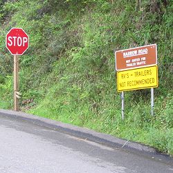
Sycamore Canyon Road to Pfeiffer Beach meets Highway 1 at 0.6 miles (1 km) south of Big Sur Station and immediately north of the Highway 1 bridge over Pfeiffer Canyon. I seem to recall from past trips to Big Sur that there was a street sign at this intersection with Highway 1, but there was no such sign in March 2005; the only way to identify the turn is to know where it is and what it looks like. See the photo here and note the Location data on this page.
This is a one-lane paved road for 2.5 miles (4 km) down to Pfeiffer Beach; use caution. In California, downhill traffic on one-lane roads must yield the right of way to uphill traffic. As the sign reads, RVs and trailers are not recommended on this side road. Pfeiffer Beach is under the jurisdiction of the Monterey Ranger District, Los Padres National Forest, U.S. Forest Service. The services shown here are at the beach except for the seasonal public transit stop.
Reference
- Day use fee
- Pfeiffer Beach day use area is located within Los Padres National Forest and is managed by Parks Management Company.
- Information from Los Padres National Forest 831.667.2315 (Big Sur Station) or 831.385.5434
- Information from Parks Management Company 805.434.1996
Activities, Facilities, and Services
- Restrooms
- Public Transit stop (seasonal, at Highway 1)
- Scenic Vistas
- Wildlife Viewing
- Hiking and Backpacking
- Coastal Access (access to the beach for the mobility-disabled via a balloon-tire wheelchair; another person in your party must push it)
- Fishing
- Surfing
Location
- Marker: MON 45.64
- Ends:
- 27 miles (43 km) from N
- 62 miles (100 km) from S
- Geo: Lat N 36° 14.416 Lon W 121° 46.637
- Google map
- Aerial coastal photos
Has this Web site, A Guide to California's Big Sur, been worth something to you as you plan a trip to Big Sur -- maybe fifty cents? a dollar? If so, you can, if you wish, contribute that amount to help defray this site's costs. Learn how.

