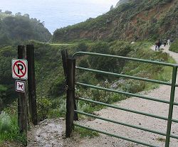
Along the Highway
Partington Canyon Trail (Julia Pfeiffer Burns State Park)
Partington Canyon Trail in Julia Pfeiffer Burns State Park begins on the west shoulder of Highway 1, at the north end of the highway bridge over Partington Canyon, about 1.9 miles (3km) north of the main entrance to this state park. It descends about 200 vertical feet (about 63 meters) to sea level at the western Partington Cove, then passes through a rock tunnel to reach the eastern Partington Cove at Partington Landing.
Tan Bark Trail begins on Highway 1's east shoulder at the south end of the highway bridge. Its 3.3 miles leads to Tin House.
Activities, Facilities, and Services
- Scenic Vistas
- Wildlife Viewing
- Hiking and Backpacking: Partington Canyon Trail, Tan Bark Trail. For more detailed information, contact Big Sur Station and see the resources listed on the Books and Maps page.
- Coastal Access
- SCUBA: Julia Pfeiffer Burns Underwater Area. A special-use dive permit is required; contact Big Sur Station.
Location
- Marker: MON 37.8
- Ends:
- 35 miles (56 km) from N
- 54 miles (87 km) from S
- Geo: Lat N 36° 10.614 Lon W 121° 41.66
- Google map
- Aerial coastal photos
Has this Web site, A Guide to California's Big Sur, been worth something to you as you plan a trip to Big Sur -- maybe fifty cents? a dollar? If so, you can, if you wish, contribute that amount to help defray this site's costs. Learn how.
