Trails and the Backcountry
The Lakes Basin Path is a paved, multiple-use path connecting commercial Mammoth Lakes with the Mammoth Lakes Basin. Aligned at the edge of Lake Mary Road, this path is open to walkers and hikers, dogs on leash, cyclists and equestrians. Its lower segment opened in 2010, and as of late August 2011 was complete from Main Street and Minaret Road all the way to Horseshoe Lake. On the way it passes Twin Lakes, Lake Mary, and Lake Mamie, and it ends at Horseshoe Lake. The Lakes Basin Path is itself an excellent recreational and scenic trail, and it also provides access to other Mammoth Lakes trailheads without the need for motor vehicles.
Here are some popular day hikes in the Mammoth Lakes area. Obtain details at the Mammoth Ranger Station. The distances shown are one way distances in miles, measured from the trailhead. Some of these trails also provide access to the backcountry for longer, overnight trips (for which a wilderness permit is required).
East of the Sierra Crest
- Earthquake Fault Trail (very short loop). This clearly-marked feature, really a "fissure" rather than a fault, is on the right side of Minaret Road, just past the Mammoth Scenic Loop Road junction, as you drive from town toward the Mammoth Mountain Main Lodge.
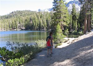
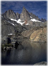
Barrett Lake
- Panorama Dome (0.5 mile, one way). From the top you have a view of town, the Owens Valley, Crowley Lake, and the Mammoth Lakes Basin. The trailhead is just past the turnoff to Twin Lakes on Lake Mary Road.
- Crystal Lake / Mammoth Crest Trail. The trailhead is to the right of the parking lot entrance at Lake George.
- Crystal Lake and Crystal Crag (1.75 miles, one way).
- Mammoth Crest (3 miles, one way). At the crest are views of the Minarets, Mammoth Mountain, and the Mammoth Lakes Basin. Experienced dayhikers can turn left at the crest and follow a trail to Deer Lakes.
- Barrett Lake / TJ Lake Trail. The trailhead for these destinations is to the left of the parking lot entrance at Lake George, near the entrance to the campground.
- Barrett Lake (0.25 mile, one way). From Barrett Lake you can follow a connecting trail to Emerald Lake and Sky Meadows.
- TJ Lake (0.5 mile, one way). Continue past Barrett Lake to reach TJ Lake.
- Emerald Lake / Sky Meadows Trail. The trailhead for these destinations is at the southwest edge of the Coldwater Creek parking lot. This lot is at the top of Coldwater Creek campground at the far (southeast) end of Lake Mary. On the way to Emerald Lake you pass a connecting trail to Barrett Lake.
- Emerald Lake (1 mile, one way).
- Sky Meadows (2 miles, one way).
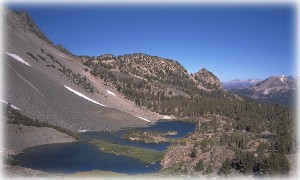
Looking north from Duck Pass Trail on the north side of Duck Pass
- Duck Pass Trail. The trailhead for these destinations is at the southwest edge of the Coldwater Creek parking lot. This lot is at the top of Coldwater Creek campground at the far (southeast) end of Lake Mary. You will pass several lakes on the way to the pass. Duck Lake lies beyond and below Duck Pass; the lake cannot be seen from the pass, but continuing south a short distance gives you a fine view.
- to Arrowhead Lake (1.25 miles, one way)
- to Skelton Lake (1.5 miles, one way)
- to Barney Lake (2.5 miles, one way)
- to Duck Lake (5 miles, one way)
- Mammoth Pass Trail. The trailhead is at Horseshoe Lake.
- Mammoth Pass Trail to McLeod Lake (spelled "McCloud" on some maps) (0.5 mile, one way).
- Mammoth Pass Trail to Reds Meadow (3.5 miles, one way). This westbound route crosses the crest and makes a long descent to Reds Meadow. You can ride the shuttle bus from Reds Meadow to Mammoth Mountain Main Lodge, but you will need your own transportation to return to Horseshoe Lake.
- Mammoth Mountain Main Lodge Trailhead
- Main Lodge Trail to McCoy Station (2 miles, one way). You can ride the Panorama Gondola in one direction between McCoy Station and Mammoth Mountain Main Lodge Panorama Station and hike in the other direction. Purchase tickets at Panorama Station.
- St. Anton Trail to McCoy Station (3 miles, one way). You can ride the Panorama Gondola in one direction between McCoy Station and Mammoth Mountain Main Lodge Panorama Station and hike in the other direction. Purchase tickets at Panorama Station.
- St. Anton Trail and Mammoth Mountain Trail to Mammoth Mountain summit (5 miles, one way). You can ride the Panorama Gondola in one direction between the summit and Mammoth Mountain Main Lodge Panorama Station and hike in the other direction. Purchase tickets at Panorama Station.
- Mammoth Mountain Inn to Minaret Vista (1.5 miles, one way). The trail begins behind Mammoth Mountain Inn and ascends through forest to Minaret Vista on the Sierra Crest.
- Dragons Back / Twin Lakes Trail to Mammoth Mountain summit (5 miles, one way). The trailhead is at Twin Lakes, near Tamarack Lodge and Resort. You can ride the Panorama Gondola from Mammoth Mountain Main Lodge Panorama Station to the summit and hike downhill to the Twin Lakes trailhead, or vice versa, but you will need two vehicles because the Main Lodge and the trailhead are on opposite sides of Mammoth Mountain. Purchase tickets at Panorama Station.
West of the Sierra Crest
Most of these trails begin at or near the Devils Postpile Ranger Station, so the online Devils Postpile park map (716kb image) will be useful to you. The map shows the shuttle bus route and stops.
Shadow Lake seen from the Pacific Crest Trail
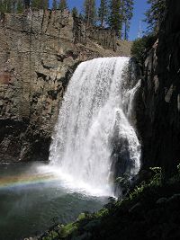
Upper Rainbow Fall
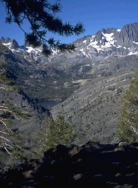
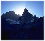
The Minarets from Minaret Lake
- Shadow Lake/River Trail. The trailhead is at Agnew Meadows Campground; use shuttle bus stop 1.
- Shadow Lake/River Trail to Shadow Lake (3.5 miles, one way). This westbound trail descends into and crosses the canyon of the San Joaquin River before climbing into the Ritter Range. The trail follows an exposed face and climbs steep switchbacks, so it is best to avoid the middle of the day, and take plenty of water.
- Shadow Lake/River Trail to Lake Ediza (6.5 miles, one way). Continue past Shadow Lake to reach Lake Ediza, set among high mountain meadows at the foot of Mt. Ritter.
- Starkweather Trail (2.5 miles, one way). The trailhead is across the road from Starkweather Lake; use shuttle bus stop 2. The trail ascends to the ranger booth/gate on the road at Minaret Summit. If you have a shuttle bus pass, you can park your vehicle at Minaret Vista, or park it at Mammoth Mountain Main Lodge Panorama Station and hike on the trail to Minaret Vista, follow this trail downhill to Starkweather Lake and shuttle bus stop 2, and take the bus back to your vehicle.
- Devils Postpile Trail. The trailhead is at the Devils Postpile Ranger Station; use shuttle bus stop 6. Walk south (downstream) from the ranger station on the signed trail.
- Devils Postpile (0.4 mile, one way). The main trail leads to an interpretive panel at the foot of the postpile formation. Just before you reach that location, a steep side trail to the left will take you to the top of the formation so you can see the "parquet floor" appearance of the column tops.
- Upper Rainbow Fall (2.5 miles, one way, from the trailhead). Continue downstream from either the foot or the top of the Devils Postpile formation. At upper Rainbow Fall the San Joaquin River plunges 101 feet (30.8 m) into a gorge. The rainbow colors in the spray are best seen at midday. You can continue downstream from here to the smaller lower fall.
- Minaret Falls/Lake Trail. The trailhead is at the Devils Postpile Ranger Station; use shuttle bus stop 6. Walk south (downstream) from the ranger station on the signed trail towards Devils Postpile. After about 0.3 mile, veer right on the signed trail, cross the river on the bridge, and continue upstream on that side.
- Minaret Falls (1.5 miles, one way). Follow the signed route upstream from the bridge. Turn right at a junction to reach the falls.
- Minaret Lake (6.2 miles, one way). Follow the signed route upstream from the bridge. At the junction at which those going to Minaret Falls go right, you continue straight ahead. The trail follows Minaret Creek to the west and reaches Minaret Lake, set in dark rock at the foot of the Minarets.
- Sotcher Lake (1.25-mile loop, self-guided). The trailhead is at the lake's picnic area; use shuttle bus stop 7.
- Rainbow Falls Trail. The main trailhead is at shuttle bus stop 9, but you can also begin and end at the Reds Meadow Pack Station near shuttle bus stop 10, where supplies and snacks are available at the resort store.
-
Upper Rainbow Fall (1.3 miles, one way). At upper Rainbow Fall the San Joaquin River plunges 101 feet (30.8 m) into a gorge. The rainbow colors in the spray are best seen at midday. You can continue downstream from here to the smaller lower fall.
For information about mountain biking in the Mammoth Lakes area, investigate the Bike Park on Mammoth Mountain and Mammoth Lakes Area Mountain Biking on trails.com.
The Mammoth Lakes area of Inyo National Forest is home to the Ansel Adams Wilderness Area and John Muir Wilderness Area. Here, the John Muir Trail and the Pacific Crest Trail pass the Sierra's Ritter Range (the Minarets and Mts. Ritter and Banner), said to be the core of a mountain range that existed long before the Sierra Nevada appeared.
A wilderness permit is required for any overnight wilderness travel, but is not required for day hikes with the exception of travel into the Mt. Whitney Zone, far to the south of the Mammoth Lakes area. The Inyo National Forest Web site also contains information about wilderness permits.
There are commercial services that provide guided wilderness travel in the Mammoth Lakes region; see Seasonal Recreation on the "Other Recreation, Entertainment, and Services" page.
Consult SierraWild.gov, your official government source for backcountry trip planning in the Sierra Nevada's National Parks, National Forests, and other public lands.
Late afternoon in the Minarets
A wilderness permit is required for overnight wilderness travel. See the Inyo National Forest Service Web site.
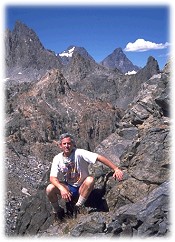
The author at (trailless) Nancy Pass
Mammoth Ranger Station
The Mammoth Ranger Station is located on CA-203 at the east edge of the town of Mammoth Lakes, on the north side of the road. You may contact this office to obtain any available unreserved permits for overnight entry into the Inyo National Forest on wilderness trails only the day before or the day of your entry.
Note: Other trails may be under the jurisdiction of another National Forest ranger district or of a National Park.
Devils Postpile National Monument Ranger Station
The Devils Postpile National Monument Ranger Station is located near Reds Meadow. To reach it, take the shuttle bus from Mammoth Mountain Ski Area. You may be able to obtain permits at this office, for trips originating in Devils Postpile only, the day before or the day of your entry.
The June Lake/Mammoth Lakes area is unusual in that the John Muir Trail and Pacific Crest Trail travel separately through much of the area rather than on the same alignment. The trails enter the area from the north over Donohue Pass, crossing the Sierra Crest from the west from Yosemite National Park, and passing the June Lake area.
 and Pacific Crest Trail (PCT) diverge at Thousand Island Lake") They then enter the Mammoth Lakes area and re-cross the Sierra Crest to the west at Island Pass, and descend to the outlet of Thousand Island Lake, at which point they separate from each other.
They then enter the Mammoth Lakes area and re-cross the Sierra Crest to the west at Island Pass, and descend to the outlet of Thousand Island Lake, at which point they separate from each other.
The trails enter the area from the south in the Duck Lake area, passing west of the Mammoth Crest and Mammoth Mountain and dropping into the valley of the San Joaquin River's Middle Fork. After crossing the river to the west, they travel north to a point just west of the Devils Postpile National Monument roadhead, at which point they separate from each other.
Between Thousand Island Lake and Devils Postpile, the John Muir Trail remains largely on the eastern shoulder of the Ritter Range, climbing in and out of small side canyons and passing many lakes. In stark contrast, the Pacific Crest Trail travels north of Devils Postpile for some distance deep in the valley of the Middle Fork. Coming abreast of the Agnew Meadows roadhead area, it switchbacks steeply up the eastern canyon wall to reach it, then continues up the canyon wall and then northward, contouring ever higher just below the Sierra Crest.
As it does so, the Pacific Crest Trail gains an awesome perspective on the Ritter Range in full view to the west across the gorge of the Middle Fork, reminding the hiker of taking a sightseeing flight in a small aircraft. For some time, the waters of Shadow Lake are in full view below the hiker and just over one mile away across the gorge. Finally, the Pacific Crest Trail contours around the head of the river valley to the west to reach Thousand Island Lake, and rejoins the John Muir Trail.