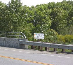
Along the Highway
Carmel River Bridge
Carmel River Bridge is the arbitrarily-defined north end of the Big Sur region for the purpose of this Guide. This unremarkable concrete highway bridge occupies a location in this Guide not for its scenic value but only because many services for the visitor are near here. This location is a short distance south of Rio Road, where there is a large commercial area on the east side of Highway 1. The facilities and services listed here may be available in that shopping area or elsewhere in adjacent Monterey, Pacific Grove, Pebble Beach, and Carmel-by-the-Sea.
Activities, Facilities, and Services
- Lodging - Accommodations - Hotels - Resorts - Motels - Inns - Cabins
- Restaurants - Food
- Restrooms
- Telephone Services
- Supplies
- Post Offices: 3845 Via Nona Marie, Carmel CA 93923 [ map ]
- Public Transit stop (seasonal)
- Gasoline (includes diesel in nearby Monterey and Carmel-by-the-Sea)
- Emergency and Medical Services: Community Hospital of the Monterey Peninsula, Monterey, 831.624.5311
Location
- Marker: MON 72.3
- Ends:
- 0 miles (0 km) from N
- 89 miles (143 km) from S
- Geo: Lat N 36° 32.18 Lon W 121° 54.754
- Google map
- Aerial coastal photos
Has this Web site, A Guide to California's Big Sur, been worth something to you as you plan a trip to Big Sur -- maybe fifty cents? a dollar? If so, you can, if you wish, contribute that amount to help defray this site's costs. Learn how.
