Along the Highway
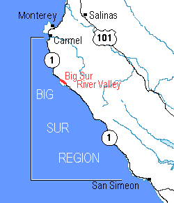
California's scenic Highway 1 is the only road through the Big Sur region. Travelers, like residents, go from where they are to almost every other point in the region on Highway 1. As a result, it is convenient to describe Big Sur's points of interest to the traveler as points along the line of Highway 1.
In these Along the Highway pages of this Guide, each major location the traveler encounters along California Highway 1 in the Big Sur region is located and described. Links are provided to the other sections of the guide and to selected relevant sites elsewhere on the Web.
Follow a link to a location that interests you.
This list is sorted from south to north.
[Show this list sorted from north to south.]
- Hearst Castle® vicinity
- Point Piedras Blancas Vista Points
- Piedras Blancas
- Ragged Point Inn vicinity
- Salmon Creek Trailhead
- Buckeye Trailhead
- Soda Springs Trailhead
- Cruickshank Trailhead
- Gorda
- Willow Creek Vista Point and Picnic Area
- Jade Cove
- Plaskett Creek Campground
- Sand Dollar Beach Picnic Area
- Pacific Valley Information Station
- Mill Creek Day Use Area
- Nacimiento-Fergusson Road
- Kirk Creek Campground
- Limekiln State Park
- Lucia
- North Gamboa Vista Point
- Big Creek Bridge
- Slates Hot Springs vicinity
- Julia Pfeiffer Burns State Park
- Burns North Vista Point (Julia Pfeiffer Burns State Park)
- Partington Canyon Trail (Julia Pfeiffer Burns State Park)
- Coast Gallery and Cafe vicinity
- Deetjen's vicinity
- Henry Miller Library vicinity
- Nepenthe and Hawthorne vicinity
- Big Sur River Valley
- Post Ranch and Ventana vicinity
- Big Sur Center and Loma Vista vicinity
- Sycamore Canyon Road (to Pfeiffer Beach)
- Big Sur Station
- Pfeiffer Big Sur State Park
- Fernwood vicinity
- Ripplewood and Glen Oaks vicinity
- Riverside Campground and Cabins vicinity
- Big Sur Campground and Cabins vicinity
- Big Sur River Inn vicinity
- Andrew Molera State Park / Coast Road (south end)
- Point Sur Lightstation State Historic Park
- Little Sur River Bridge
- Hurricane Point
- Bixby Creek Bridge / Coast Road (north end)
- Rocky Creek Bridge
- Palo Colorado Road (to Bottchers Gap)
- Rocky Point
- Abalone Cove Vista Point
- Garrapata State Park
- Carmel Highlands
- Point Lobos State Reserve
- Carmel River State Beach (south access)
- Carmel River Bridge
Can't find it?
If you're looking for something specific on this Web site about Big Sur and have not found it yet, try the It's Not Here page or the Search this Web site page.
Has this Web site, A Guide to California's Big Sur, been worth something to you as you plan a trip to Big Sur -- maybe fifty cents? a dollar? If so, you can, if you wish, contribute that amount to help defray this site's costs. Learn how.

